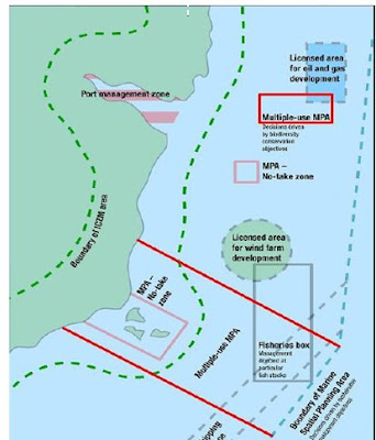
In terms on CZM identifying all paricipants and conflict pressure points. (See below)
Climate change Vs Coastal defence
Dredging Vs Coastal erosion
Designation Vs Comercial fishing
Tourism Vs Bathing Waters
Infrastructure development Vs Run-Off
Agricultural Vs Waste Managment
Habitat conservation Vs legislative powers
Marine Spatial Planning Vs Navigation
The above list of conflicts is summarised from examination below possible strategy and approaches followed by case study summary.
- Consider the coastal area as a dynamic natural landscape.
- Make only interventions in the coastal processes and in the coastal landscape if the interests of the society are more important than preserving the natural coastal resource.
- Appoint special sections of the coast for natural development.
- Demolish inexpedient old protection schemes and re-establish the natural coastal landscape where possible.
- Minimise the use of coastal protection schemes, give high priority to the quality of the coast resource, and concentrate on shore protection.
- Preserve the natural variation in the coastal landscapes.
- Restrict new development/housing close to the coastline in the open uninhabited coastal landscape. Allow only such facilities, which require access to the sea.
- Maintain and improve the public access to and along the beach, legally as well as in practice.
- Reduce pollution and enhance sustainable utilisation of coastal waters.
The factor of strategy to implementation of Marine Spatial Planning was my focus within the exam and the Devon form/Lyme Bay were the main refrerences sources.
Defintion of Marine Spatial Planning
A marine spatial planning system – a planning system for the sea – to enable strategicand integrated plan-led management of sea use at the UK, national, regional and evenlocal levels. Marine spatial planning must be multi-use planning, and the spatial planareas should not be confined to geo-political boundaries, but based on marineecosystems or other meaningful geographical units. A “regional sea” approach, suchas that being tested through the Defra-led Review of Marine Nature Conservation(RMNC) Irish Sea Pilot Study, may be the most appropriate for marine spatial planning,and will require both a UK-wide and national marine policy as well as marinelegislation.
Personal aspirations after year of study:
The chance to be involved in a world changing aspect of science and management is inspiring and through out the year intrest in all areas of this subject have encouraged me to gain my degree at the university of Plymouth with future plans to gain work experience across the globe.
Possible employment:
Coastal Surveyor : Description
We are looking for energetic, scientifically minded, motivated people with good communication skills. You will be working as part of a new team at the forefront of this work in the UK. Your main functions will be to collect, manage, process and analyse coastal data.
Environmental Consultatiom:

 The convergence of these protected area schemes through relation of such directives into a marine spatial planning using a streamline of a single body may allow an increase in efficiency to allow more sustainable of conservation to produce a effective answer to the protection of marine bio-diversity.
